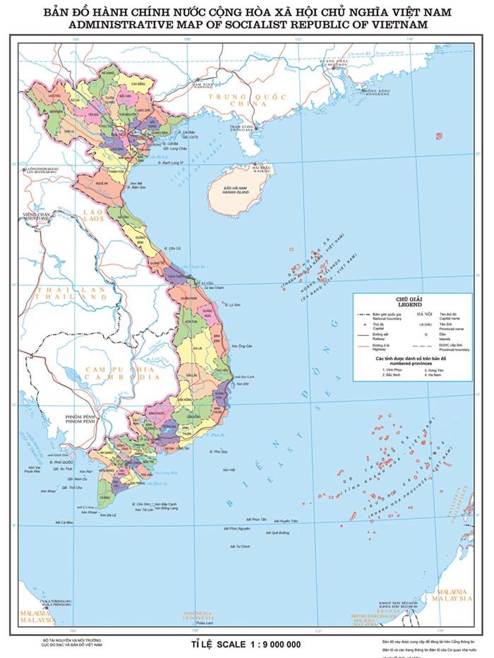
Vietnam is a Southeast Asian country belonging to the Indochinese peninsula. Currently, Vietnam has 63 provinces and cities, including 58 provinces and five cities (Hanoi, Hai Phong, Da Nang, Ho Chi Minh City, and Can Tho), with Hanoi as the capital.
Join us in studying the Vietnam map, which provides valuable natural, cultural, and socio-economic information.
Vietnam map
A general overview of Vietnam’s geography
Vietnam maps are constantly updated to provide detailed information relevant to the reality and development situation of all localities in the country.
First of all, according to the latest data updated in 2020, Vietnam’s total population is more than 97 million people. It has the 15th highest population density in the world and a natural area of 331,698 km2.
Vietnam’s terrain consists mainly of hills and mountains, which account for a quarter of the area, while the plain and midland terrain account for only a quarter of the country.
Therefore, the majority of provinces and cities in Vietnam have quite diverse natural topography, and economic zones are also divided by topography.
Based on geographical features, Vietnam’s map has three regions, including the North, Central, and South, and seven critical economic areas.
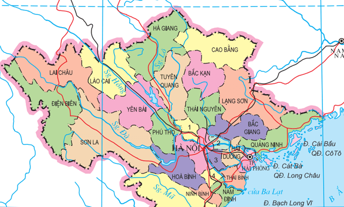
Map of Northern provinces and cities
North Vietnam is considered the heart of the country, covering the political, economic, and cultural center, typically owning Vietnam’s capital, Hanoi.
Based on the natural topography and economic characteristics of each area, the North continues to be divided into three key economic regions, including the following specific provinces:
The Northwest includes 6 provinces: Hoa Binh, Son La, Dien Bien, Lai Chau, Lao Cai, and Yen Bai.
The Red River Delta comprises 10 provinces and cities: Hanoi, Ha Nam, Ninh Binh, Bac Ninh, Hai Duong, Hai Phong, Hung Yen, Nam Dinh, Thai Binh, and Vinh Phuc.
The Northeast includes 9 provinces: Ha Giang, Cao Bang, Bac Can, Lang Son, Tuyen Quang, Thai Nguyen, Phu Tho, Bac Giang, and Quang Ninh.
Natural beauty and traditional culture of North Vietnam
Traveling to the North of Vietnam, you will discover the beautiful natural landscapes and many impressive architectural works created by skillful human hands.
Like a masterpiece among thousands of clouds, Fansipan in Sa Pa (Lao Cai) is one of the well-known places on their journey to discover the Northwest. On cold days, clouds flowing down from the top of the mountain look like white waterfalls.
Visiting Moc Chau, once admiring the dreamy plateau in the morning mist, you will be amazed by the magical and attractive beauty of the immense steppe and the vast tea hills in the white mist.
Down to the South, the rich Bac Son valley is between the four sides of limestone mountains, adorned by rivers winding through rice fields stretching vastly, creating a charming picture.
Ha Giang is also a popular destination in the North, attracting anyone who comes here because of its vast and stunning flower fields every autumn.
Going down the Ngo Dong River to visit Tam Coc, you will be surprised at the harmony of colors here. In the harvest season, the scene of the jade-green river, flowing between the golden fields and fragrant with the smell of ripe rice, creates a beautiful picture of the countryside.
Returning to Hanoi’s rich culture, you can visit ancient pagodas and long-standing craft villages that have become a beauty of national culture. It would be best to take advantage of stopping at Bat Trang Pottery Village.
Map of Central Provinces
Similar to the North, the provinces of Central Vietnam are one of the seven vital regions of the country, divided into three smaller economic areas.
The North Central region includes 6 provinces: Thanh Hoa, Nghe An, Ha Tinh, Quang Binh, Quang Tri, and Thua Thien-Hue.
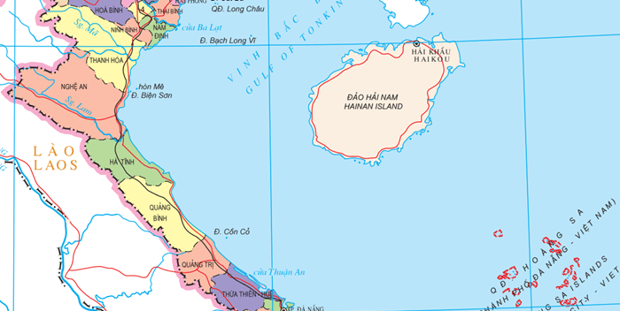
South Central Coast includes 8 provinces: Da Nang, Quang Nam, Quang Ngai, Binh Dinh, Phu Yen, Khanh Hoa, Ninh Thuan, and Binh Thuan.
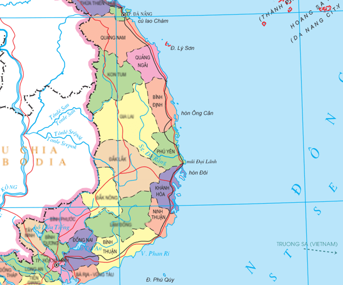
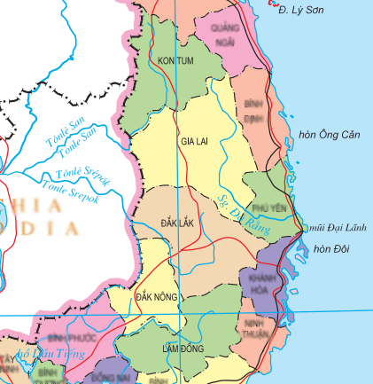
The Central Highlands is the largest plateau area in Vietnam, covering 5 provinces stretching from North to South, namely Kon Tum, Gia Lai, Dak Lak, Dak Nong, and Lam Dong.
Peaceful scenery on the arid, harsh Central land of Vietnam
Despite the arid land and harsh weather, the central region of Vietnam is still an attractive destination full of charm for tourists.
Quang Binh is famous for its splendid caves, which are like heaven on earth. You will be amazed by the mysterious beauty of Thien Duong Cave, the romantic river to Phong Nha Wet Cave, and Son Doong Cave, which has a unique primeval forest inside.
Going to Ru Cha forest in Hue, you can walk on the narrow path under eye-catching green leaves to admire the hundred-year-old tree roots.
Besides, the long and pure white salt fields and the brilliant golden sunlight on the glossy water surface have created the unique beauty of nature in Hon Khoi, also named Yen Cang, located in the east of Ninh Hoa district, Khanh Hoa province, Vietnam.
No noise, no show, Hoi An in Quang Nam Province is captivated by its ancient, quiet beauty, moss-covered red tile roofs, and the road filled with red lanterns. In addition, you can also choose to visit the grasslands or watch the sunrise at Cua Dai – one of the beautiful beaches in Hoi An, which is a great way to enjoy the beauty of Quang Nam.
There is no need to dive deep into the seafloor. Visitors to Hon Yen (Phu Yen Province) can easily see the beautiful coral reefs under the clear seawater at low tide.
Gia Lai land is the place to immerse yourself in the unique gong festival in the Central Highlands and have exciting experiences exploring the mountainous life of the locals.
Stopping in Phan Thiet and visiting Ke Ga fishing port is also a great place to enrich your journey.
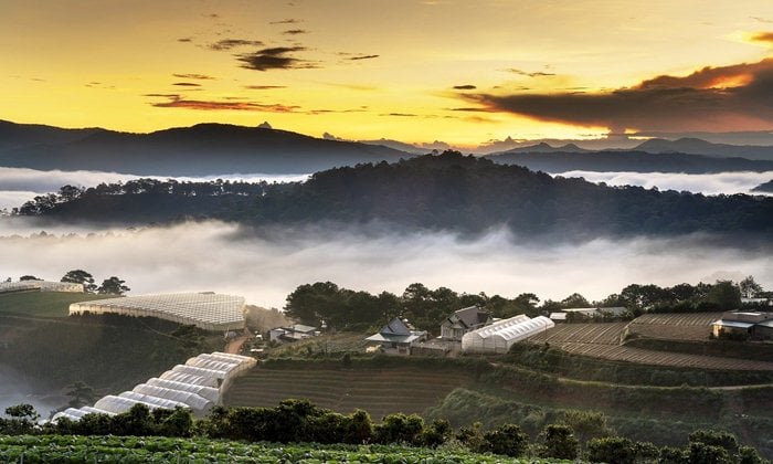
Da Lat attracts tourists with its natural beauty, including Tuyen Lam Lake, Langbiang Mountain, and Pongour waterfall—one of the most famous waterfalls in Vietnam.
At the end of the trip to explore Central Vietnam in Phan Rang, you can visit Nam Cuong dunes to see the sunset view. Look at the wild beauty of the golden sand and experience the feeling of loss among thousands of sheep.
Map of Southern provinces and cities
The last region of the Vietnam map is the southern part, which includes two vital economic regions: the Southeast and the Southwest.
With typical features of South Vietnam, it creates strong development potential for the whole South of the country.
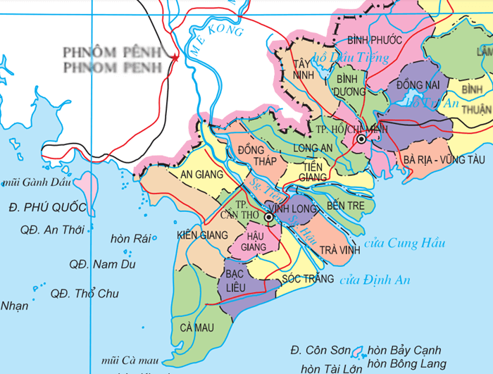
The Southeast includes 1 city and 5 provinces: Ho Chi Minh City, Ba Ria – Vung Tau, Binh Duong, Binh Phuoc, Dong Nai, and Tay Ninh.
The Southwest is also the Mekong Delta region, including a centrally-run city, Can Tho, and the 12 remaining provinces of Long An, Tien Giang, Ben Tre, Vinh Long, Tra Vinh, Hau Giang, Soc Trang, Dong Thap, An Giang, Kien Giang, Bac Lieu, and Ca Mau.
South Vietnam: a vivid picture from the modern rhythm of life to the rustic countryside
South Vietnam offers different emotions at each destination. You can immerse yourself in the vibrant life of Ho Chi Minh City or explore the rustic countryside along the Mekong rivers.
In the floating season, do not hesitate to stop at Long An, a land known for its fields of water lilies.
In the beautiful picture of nature, the hidden palm trees and rice fields stretching to the horizon always captivate tourists when they come to Tinh Bien in An Giang Province.
Each province on the Vietnam map has its own characteristics. But, all places constitute resources for the economic development of the country.
The above is a statistic of some economic, social, and geographic information about different regions across the country. Vietnamdrive will give you more helpful information and an overview of the provinces and cities in Vietnam.
Frequently asked questions about the Vietnam map
1. What does the Vietnam map look like?
When you want to find Vietnam on the world map, look for a country shaped like the letter S, which is Vietnam.
The north is large, the middle part is small and gradually widens to the south.
2. Where is the narrowest place on the map of Vietnam?
The narrowest area in the east-west direction is located in Quang Binh, central Vietnam, which has a beautiful paradise cave.
This region owns a width of about 41km from the Laos-Vietnam border to the East Sea.
3. Which province in Vietnam has the largest acreage?
Many people think that Hanoi or Ho Chi Minh is the largest, but that is not the case. Those two cities have the biggest populations.
However, Nghe An province is the largest region in Vietnam, with a total area of 16,493 km2.
Nghe An province is located in the North Central region, bordering Thanh Hoa to the north, Ha Tinh to the south, the East Sea to the east, and Laos to the west.
4. Which is the longest road in Vietnam?
The National Highway 1A, or QL1A, is the main road along Vietnam. At 2,360km, it is the longest street in the country.
Highway 1A starts from the Huu Nghi border of Vietnam and China in the north and ends at Nam Can District, Ca Mau Province in the Mekong Delta.