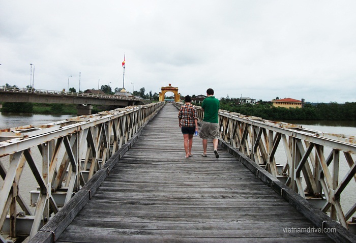
Hien Luong Bridge at DMZ Vietnam
Hien Luong Bridge at DMZ Vietnam is over the Ben Hai River at kilometer 735 of Highway No.1. This bridge is the joining point of the Hien Luong commune in the North and Xuan Hoa commune in the South. It is 10 kilometers away from Cua Tung Beach in the west.
Hien Luong Bridge – Photo by Vietnamdrive
The history of the Hien Luong Bridge
Formerly, the river was 100 meters wide, and the ferry was the only means of transport.
In 1928, the Vinh Linh authority mobilized people to build a bridge of 2 meters wide of the steel frame, which was strong enough for only pedestrians.
In 1931, France rehabilitated the bridge, but cars or heavy means of transport still had to take the ferry.
In 1943, the bridge was upgraded, and light means of transport could cross it.
In 1950, due to military purposes, France built a concrete bridge 162 meters long and 3.6 meters wide, which could hold the weight of 10 tons. This bridge existed for two years and was blown up because of our guerilla’s explosion.
In May 1952, France rebuilt a new bridge here. The bridge was 178 meters long, with seven spans, and its skeleton was stolen. The surface was paved with pinewood and 4 meters wide. The rails of the two sides were 1.2 meters high, and the bridge could hold 18 tons of weight.
Nguyen Tuan, a writer, described this bridge as “divided into two parts. Each part was 89 meters and painted in different colors, respectively. The northern part of the bridge was paved with 450 wood planks and the southern part with 444 wood planks”. This bridge existed for 15 years (1952-1967) and then collapsed by bombs of the US.
From 1972 to 1974, to serve the South battlefields, we built a temporary bridge 20 meters away from the old one to the west. In 1974, we built a new concrete bridge 186 meters long and 9 meters wide. The two sides for pedestrians’ walk are 1.2 meters wide. This new bridge is the symbol of national reunification.
After liberation, the bridge was seriously degraded. In 1996, receiving the attention of the central government, the Ministry of Transport allowed the building of a new bridge 230 meters long and 11.5 meters wide. This bridge was built to the west of the old bridge using a modern method in Vietnam.
The old bridge, built in 1974, was maintained and planned for rehabilitation. It existed from 1952 to 1967 and is the center of tourism in the DMZ and Hien Luong.
When the country was divided, the southern army painted a white line of 1cm wide in the middle of the bridge. It was not enough when the enemy painted the bridge with a different color. This meant the two sides were not the same country.
At first, they painted the southern part of the bridge a different color, which meant the two sides were not from the same country. They painted the southern part of the bridge green, and the Northern people had to paint the other part the same color. Then they used a brown color, and we had to repaint the same one.
As a result, the bridge’s paint color, Hien Luong, was different, so we had to repaint it with the same color. In the end, the enemy had to leave the bridge and did not paint a different color anymore. The bridge was not painted a different color anymore. The bridge had a green color, reflecting the color of hope and reunification.
In 13 years (1954-1967), the bridge was there, but no one crossed the bridge to see their relatives or neighbors. Only the police force was guarding the bridge. Every month, on the event date, a group of three persons of the Northern police went to the post of the Southern police to exchange work.
Hien Luong Bridge symbolized the national division. As a bridge, it should have connected the two parts of the country.
In 1967, the US bombs made the bridge collapse. This symbolized the goals of the US, which were to divide the country into the North and the South. They did not want to leave the bridge connecting the country’s two parts.
(Quang Tri Management Board of Relics and Tourist Sights)
