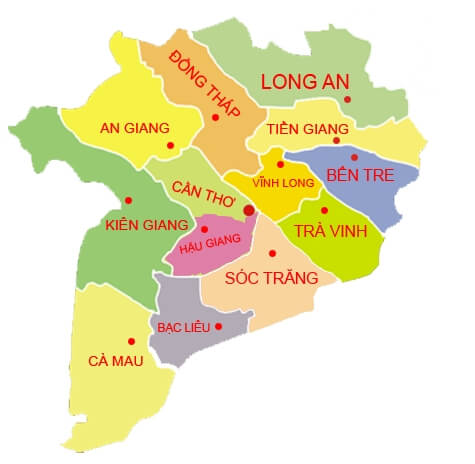
Mekong Delta in the map of Vietnam includes the provinces of Long An, Tien Giang, Ben Tre, Vinh Long, Tra Vinh, Can Tho, Soc Trang, Bac Lieu, Ca Mau, Kien Giang, An Giang, Dong Thap and Hau Giang.
The region has a total natural area of 39,734 km2, which is 12.2% of the country’s natural area.
Geography, natural conditions of the Mekong Delta
Geographical location
Mekong Delta is in the southwest end of the country, and is located at the end of the Indochina peninsula, adjacent to the Key Economic Zone of the South Vietnam.
It is bordered by Cambodia and the same Mekong River, which creates the good conditions for cooperation with countries in the Indochina peninsula.
The Mekong Delta also has the coastline of 73.2 km long and many islands such as Tho Chu and Phu Quoc island in the East Sea and the Gulf of Thailand.
The region is in the area of international maritime and air traffic between South Asia and Southeast. This position is very important in international exchanges.
Natural conditions and resources
Topographic of Mekong Delta:
The Mekong Delta of Vietnam is formed from sediment and accretion through the changing sea level; through each stage, the formation of sand dunes along the coast.
The mixed activities of the river and the sea have formed fertile alluvial lands along the river, and the coast.
The topography of the area is relatively flat; the average height is 3-5m. The area is only 0.5 – 1m above sea level.
Climate in Mekong Delta:
The humid tropical climate with equatorial equilibrium is evident. The annual average temperature is 24 – 270C. The difference in day and night temperature is low.
There are two seasons: the rainy season is from May to October, rainfall accounts for 99% of the total rainfall of the year; the dry season from December to April of the next year, almost no rain.
It is possible to say that the climatic factors of the region are suitable for the organisms to grow and develop, which is good for agriculture.
Land Conditions:
– The land conditions of Mekong Delta include:
+ Alluvial soil: Mainly distributed in the coastal zone and between the system of the Tien River and the Hau River. The area has 1.2 million hectares of alluvial soil. This soil group is highly fertile, suitable for a variety of rice, fruit trees, and short-term industrial trees.
+ Acidic soil: distributed in Dong Thap Muoi and Ha Tien. These are the central lowland of Ca Mau with the total area of 1.2 million hectares. The soil is poor.
+ Gray soil: includes the area of 134,000 ha. It covers mainly along the Cambodian border, on the ancient alluvium floor of the Dong Thap Muoi. This kind of land has light soil, spongy and low fertility.
+ There are also other soil groups such as sandy soil, red soil, and erosion soil occupying 0.9% of the area.
In general, the land here is very favorable for agricultural development, suitable for growing rice, coconut, sugarcane to make sugarcane juice and sugar, pineapple and fruit trees.
Water Resources:
Mekong Delta in Vietnam is at the lower Mekong system, including the two rivers of Tien and Hau rivers with 500 billion cubic meters. The Tien River accounts for 79%, and Hau River accounts for 21%.
Hydrological regime varies seasonally. The rainy season in September and October usually causes the flood in Dong Thap Muoi, and Long Xuyen. In this season, the river water brings a lot of silt to the plain.
In the dry season, the amount of water is lower. The tide comes into the deltas to cause the salty soils.
Marine resources:
– Coast length: 732 km with many estuaries and bays. There are many kinds of seafood: Shrimp, turtles and squids.
– There are many islands with high economic potential such as Tho Chu and Phu Quoc islands.
Mineral resources:
– The mineral reserves are not much; however, limestone is distributed in Ha Tien, Kien Luong with around 145 million tons.
This limestone is used for the production of cement, and lime. The sand is at Vam Co River, and the Mekong River with about 10 million cubic meters; and the peat in U Minh, Can Tho, Soc Trang and Long Xuyen.
>>> Do you like to read about coconut worms typical in Mekong Delta?